
Syed Shayan Real Estate Archive
Syed Shayan Real Estate Archive
From Real Estate History
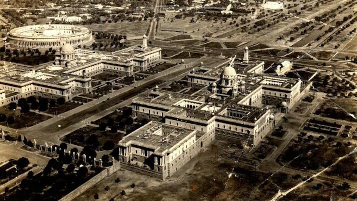
In October 1911, the British Government of India began the final arrangements to shift the imperial capital from Calcutta to Delhi. The formal announcement was made later that year in December 1911 during the Delhi Durbar in the presence of King George V. However, the initial phase of planning and land selection officially began on October 11, 1911, when a directive was issued from the office of the Viceroy, Lord Hardinge of Penshurst.
This was the day Delhi’s urban and civic identity was redefined. The British administration decided to build a new city on the western banks of the River Yamuna, which would later be known as New Delhi.
For its design, two renowned architects, Edwin Lutyens and Herbert Baker, were commissioned. They developed a master plan that was not only an architectural symbol of imperial power but also a model of modern urban planning principles.
The construction of New Delhi embodied concepts such as zoning, land acquisition, green corridors, and a radial grid of avenues. The decision introduced for the first time in the Indian subcontinent the idea of colonial planning as an architecture of power.
▪ Reference(s):
اکتوبر 1911 میں برطانوی ہند کی حکومت نے دارالحکومت کو کلکتہ سے دہلی منتقل کرنے کے حتمی انتظامات شروع کیے۔ اس فیصلے کا باضابطہ اعلان بعد میں دسمبر 1911 کے دہلی دربار میں بادشاہ جارج پنجم کی موجودگی میں کیا گیا، مگر ابتدائی منصوبہ بندی اور زمین کے انتخاب کا عمل 11 اکتوبر 1911 کو وائسرائے لارڈ ہارڈنگ کے دفتر سے جاری حکم کے ساتھ شروع ہوا۔
یہ وہ دن تھا جب دہلی کی شہری اور عمرانی شناخت ازسرِنو متعین ہوئی۔
برطانوی حکام نے دریائے جمنا کے مغربی کنارے پر ایک نیا شہر تعمیر کرنے کا فیصلہ کیا — جسے بعد میں نیو دہلی (New Delhi) کہا گیا۔ اس منصوبے کے ڈیزائن کے لیے معمار ایڈون لٹینز (Edwin Lutyens) اور هربرٹ بیکر (Herbert Baker) کو منتخب کیا گیا۔ ان دونوں نے ایک ایسا ماسٹر پلان تیار کیا جو نہ صرف شاہی اقتدار کی علامت تھا بلکہ شہری منصوبہ بندی کے جدید ترین اصولوں کی نمائندگی بھی کرتا تھا۔
نیو دہلی کی تعمیر میں زیونگ، لینڈ ایکوزیشن، گرین کورڈنز، اور سڑکوں کے ریڈیل گرڈ جیسے تصورات کو عملی شکل دی گئی۔ اس فیصلے نے ہندوستان کے شہری ڈھانچے میں پہلی بار “کولونیل پلاننگ بطور پاور آرکیٹیکچر” کا تصور متعارف کرایا۔
▪️سید شایان ریئل اسٹیٹ آرکائیو
In October 1939, as the clouds of the Second World War gathered over the Indian subcontinent, Lahore stood as the administrative and military heart of British Punjab, a thriving center of commerce, governance, and mobility. During this critical moment, the Punjab Government declared Lahore a War Time Urban Zone and instructed the Lahore Improvement Trust (LIT) to begin urgent urban replanning to meet the city’s growing strategic and civilian needs.
According to the Punjab Government Gazette issued on October 11, 1939, the LIT was directed to prepare a comprehensive plan that included new zoning, housing schemes, road expansions, and modern drainage systems for the city’s southern and western areas, particularly around Ferozepur Road, Mozang, Ichhra, and the outskirts of Model Town.
This initiative marked the beginning of modern urban planning in Lahore. It introduced, for the first time, the concept of planned urban expansion, a model that would later shape the development of Shadman, Garden Town, Muslim Town, and Gulberg.
The wartime replanning reflected a blend of British civic order, canal-based land use, and emerging defense corridors. It redirected the city’s axis of growth from the old walled core toward the south and west. It was also the first time a formal boundary was drawn between the city and the district, a line that would define Lahore’s urban identity for generations to come.
▪ Reference(s):
اکتوبر 1939 میں جب دوسری عالمی جنگ کے بادل برصغیر پر چھا گئے، لاہور برطانوی پنجاب کا نہ صرف انتظامی مرکز تھا بلکہ فوجی و تجارتی سرگرمیوں کا بھی اہم گڑھ تھا۔ انہی دنوں پنجاب حکومت نے لاہور کو “War-Time Urban Zone” قرار دیتے ہوئے لاہور امپرومنٹ ٹرسٹ (LIT) کو ہنگامی بنیادوں پر شہری ازسرِنو منصوبہ بندی (Replanning) کی ہدایت دی۔
11 اکتوبر 1939 کے پنجاب گورنمنٹ گزٹ کے مطابق، LIT کو حکم دیا گیا کہ وہ فیروزپور روڈ، مزنگ، اچھرہ، اور ماڈل ٹاؤن کے درمیانی علاقوں کے لیے نئی زوننگ، رہائشی اسکیمیں، سڑکوں کی توسیع، اور نکاسی آب کا ایک جامع منصوبہ تیار کرے۔
یہ وہ لمحہ تھا جس نے لاہور کو جدید شہری منصوبہ بندی کے دور میں داخل کیا اور پہلی بار “منصوبہ بند شہری توسیع (Planned Urban Expansion)” کا تصور متعارف کرایا — ایک ایسا ماڈل جو بعد میں شادمان، گارڈن ٹاؤن، مسلم ٹاؤن، اور گلبرگ جیسے علاقوں کی بنیاد بنا۔
یہ Replanning دراصل برطانوی دور کے شہری نظم، نہری زمینوں کے استعمال، اور دفاعی راہداریوں کے امتزاج کا مظہر تھی، جس نے لاہور کی سمت اندرونِ شہر سے جنوب اور مغرب کی جانب موڑ دی۔ یہی وہ عہد تھا جب پہلی بار “شہر” اور “ضلع” کے درمیان ترقیاتی لکیر کھینچی گئی — ایک لکیر جو بعد میں لاہور کی شہری شناخت کی اساس بنی۔
▪️سید شایان ریئل اسٹیٹ آرکائیو
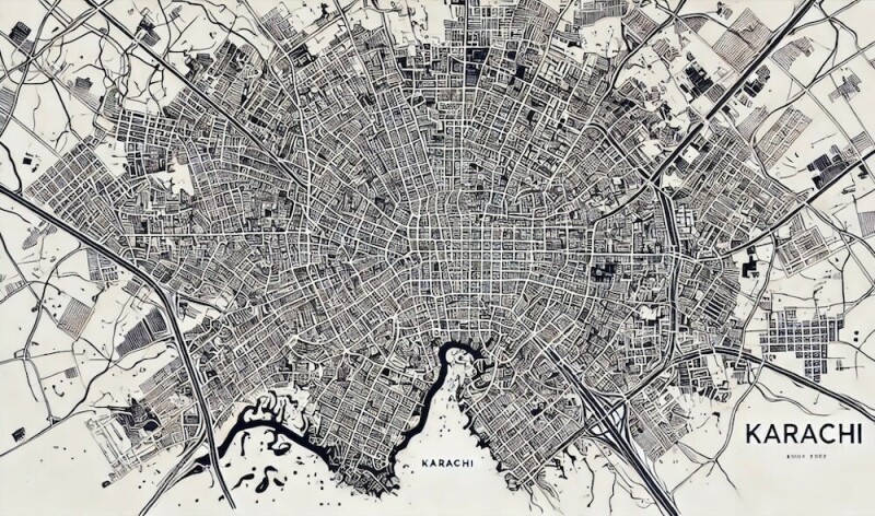
On October 11, 1955, the Federal Cabinet of Pakistan approved the formation of the Karachi Development Authority (KDA) Master Plan Unit, marking the beginning of the country’s first metropolitan level planning institution. This landmark decision came during a period of rapid urban growth as Karachi evolved into the economic and administrative center of the newly independent state.
By the mid 1950s, Karachi’s population had more than doubled since 1947 due to large scale migration, industrial expansion, and the relocation of government institutions. The city’s unplanned expansion created increasing challenges in housing, transportation, sanitation, and water supply. Recognizing the urgency of these issues, the Federal Cabinet directed the Ministry of Housing and Works to establish the Karachi Master Plan Commission, supported by the United Nations Technical Assistance Board (UNTAB).
The Commission was given the responsibility to prepare a twenty year comprehensive plan to guide Karachi’s spatial development, zoning, housing programs, and industrial growth. The Karachi Development Authority was created as the executive body to implement this plan and to coordinate future infrastructure projects. The Master Plan Unit became the core of this initiative and set a model for urban management across Pakistan.
The KDA’s vision described Karachi as a balanced coastal metropolis emphasizing organized residential clusters, industrial corridors, and modern transport systems. This vision provided the foundation for the development of satellite towns such as Korangi, Landhi, Malir, and New Karachi, designed to decentralize population and economic activity from the congested city center.
The 1955 decision transformed Karachi into South Asia’s first major postcolonial experiment in organized urban growth. It marked a shift from colonial style municipal administration to a structured institutional framework for metropolitan planning supported by both national expertise and international technical collaboration.
▪ Reference(s):
کراچی: وفاقی کابینہ نے آج کراچی ڈیولپمنٹ اتھارٹی (KDA) کے تحت ماسٹر پلان یونٹ کے قیام کی منظوری دے دی ہے۔
یہ ملک کی پہلی باقاعدہ میٹروپولیٹن منصوبہ ساز اتھارٹی ہے جو شہر کے لیے ایک جامع شہری ترقیاتی منصوبہ تیار کرے گی۔
وزارتِ ہاؤسنگ اینڈ ورکس نے اقوامِ متحدہ کے ٹیکنیکل اسسٹنس بورڈ (UNTAB) کے اشتراک سے کراچی ماسٹر پلان کمیشن تشکیل دے دیا ہے۔
کمیشن کو ہدایت دی گئی ہے کہ وہ شہر کی زوننگ، رہائشی اسکیموں، صنعتی علاقوں، اور بنیادی ڈھانچے کے لیے بیس سالہ ماسٹر پلان تیار کرے۔
آبادی میں تیزی سے اضافے، صنعتوں کے پھیلاؤ، اور سرکاری دفاتر کی منتقلی کے باعث کراچی کو پانی، صفائی، اور ٹرانسپورٹ کے سنگین مسائل کا سامنا ہے۔
نیا کمیشن ان مسائل کے حل کے لیے جامع خاکہ تیار کر رہا ہے تاکہ شہری سہولتوں میں بہتری لائی جا سکے۔
KDA کے مطابق کراچی کو ایک منظم ساحلی شہر کے طور پر ڈھالنے کا منصوبہ تیار کیا جا رہا ہے۔
رہائشی بلاکس اور صنعتی زونز کے ساتھ کورنگی، لانڈھی، ملیر اور نیا کراچی جیسے نئے سیٹلائٹ ٹاؤنز کی تعمیر کا کام بھی منصوبے میں شامل ہے تاکہ آبادی کا دباؤ مرکزی شہر سے کم کیا جا سکے۔
یہ پاکستان کے شہری ترقیاتی سفر میں ایک سنگِ میل سمجھا جا رہا ہے۔
ماہرین کا کہنا ہے کہ یہ منصوبہ کراچی کو ایک متوازن، خود کفیل اور جدید شہر میں بدلنے کی بنیاد فراہم کرے گا۔
▪️سید شایان ریئل اسٹیٹ آرکائیو
On October 19, 1923, landmark legislation for historic building preservation was enacted, creating the first comprehensive framework for protecting architecturally significant structures from demolition or inappropriate modification. This legal development emerged as rapid urbanization threatened centuries-old buildings with cultural and historical...
Read More →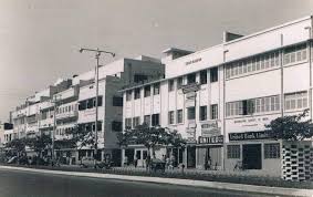
On October 25, 1967, Pakistan introduced the Urban Development and Housing Reform Act, which marked a turning point in national city planning. The legislation established urban development authorities and zoning regulations for major cities like Karachi, Lahore, and Islamabad. It promoted structured urban growth, affordable housing, and better muni...
Read More →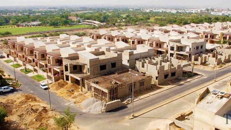
On October 30, 1980, Pakistan unveiled its groundbreaking first comprehensive national housing policy specifically designed to address the shelter needs of low-income families, representing a transformative shift in the country's approach to real estate development and urban planning. The pioneering policy established comprehensive frameworks for a...
Read More →
On October 18, 2018, the Pakistani government extended tax amnesty benefits specifically to the construction sector to stimulate economic activity and address housing shortages. The policy allowed investors and developers to declare previously undisclosed assets by investing in approved construction projects without the fear of tax scrutiny or lega...
Read More →
On October 20, 1901, the first comprehensive national building code standards were established, creating uniform construction regulations across the country. This landmark legislation addressed fire safety, structural integrity, and sanitation requirements for all new constructions. The code mandated minimum room dimensions, ventilation standards, ...
Read More →
No comments yet. Be the first to comment!